

This’ll be an interesting topic that not many of you probably know about. We see them every day and have probably wondered if there is an established study of these, and if so, what the classification system is. They’re here rain or shine and can be good predictors of if it will rain or shine. You guessed it; the topic is clouds. Let’s talk about cloud formations.
The majority of the information coming from this post is coming from this book here (https://www.amazon.com/Dangerous-Book-Boys-Conn-Iggulden/dp/0062208977/ref=sr_1_1?crid=1AVA0MYRYSJCE&keywords=the+dangerous+book+for+boys&qid=1568075233&s=gateway&sprefix=the+dangerou%2Caps%2C262&sr=8-1). There are many different combinations of cloud types but there are three basic types of clouds: cirrus, cumulus, and stratus. We’ll touch on each individual one and then talk about the different combinations that can happen between them.
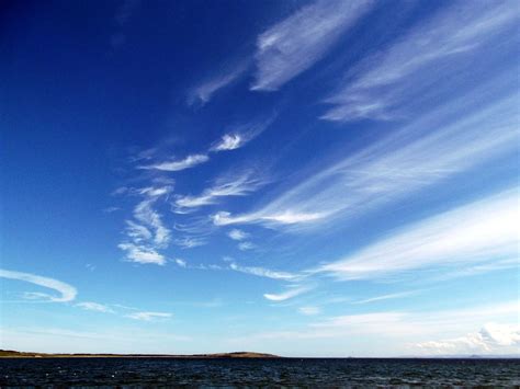
The first major type of cloud is cirrus. These are light, wispy looking clouds that form at high altitudes, above 18,000 feet. They are made from ice crystals high in the atmosphere and are sometimes referred to as “mare’s tails.”
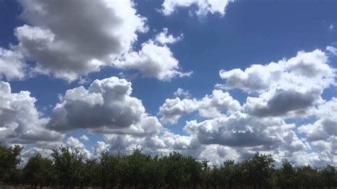
The second major type of cloud is the cumulus. These are the generic picture we get when we think of clouds. They are fluffy looking cottonball clouds that we see on most days. Cumulus would be considered a low altitude cloud formation, coming in up to 6,500 feet.
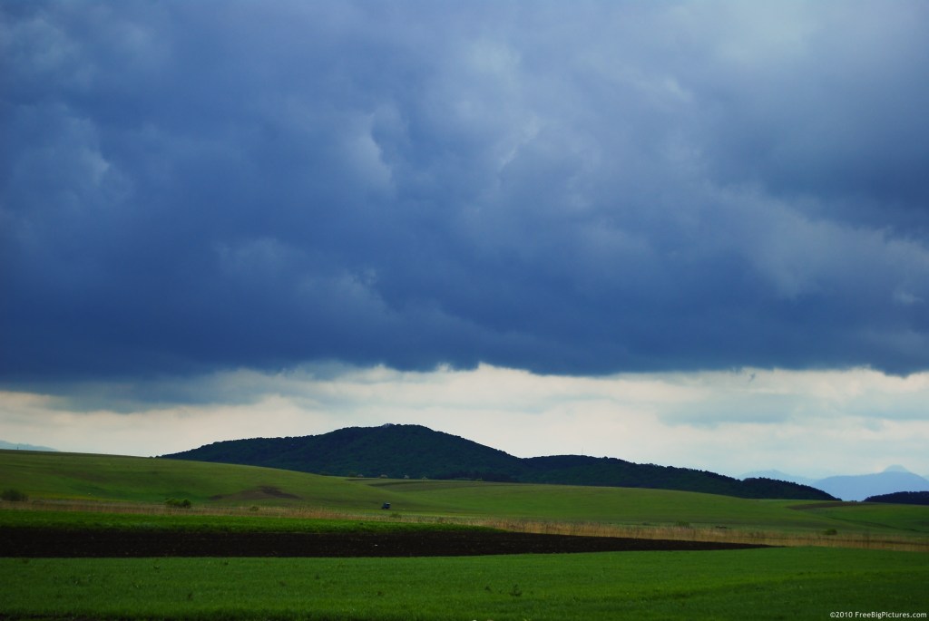
The third major type of cloud is the stratus cloud. Stratus clouds are characterized by a dark, solid blanket at low level. These clouds look very flat with no distinct features. They may not look like a typical cloud that we think of. They can look like what is essentially above-ground fog.
From here, all other cloud formations are combinations of these basic types. For example, there can be cirrostratus, cirrocumulus, or stratocumulus. There’s another major defining feature of clouds, dark grey rain clouds referred to as nimbus. This can be in combination with the major types of clouds too, like cumulonimbus and nimbostratus.
In order to prepare for unexpected rain, you should be on the look out for cumulonimbus clouds, which are cottonball storm clouds at high altitude. This is usually the leading edge of a storm. Once you see stratus and stratocumulus clouds getting lower you should start planning a course of action if it does rain. If they descend quickly into nimbostratus clouds, then it’s time to seek shelter because it’s going to rain.
There you have it, those are the basic cloud formations. I hope this post provided you with some useful information and covered a topic that you may not have known about. Thank you for stopping by and reading, there’s more to come from The Great Outdoors blog!
